
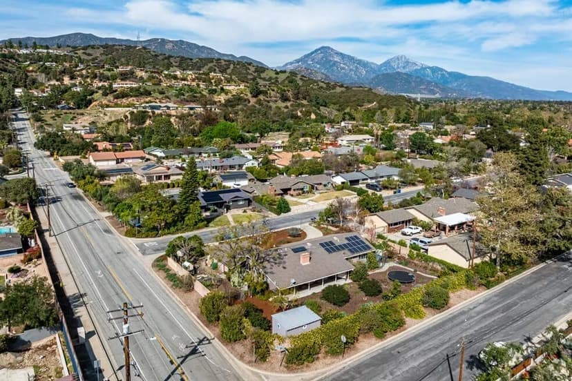
Claremont's northern boundary is not a street — it is a mountainside, and the town owns a piece of it. The Claremont Hills Wilderness Park is the city's preserved foothill open space: genuine chaparral wilderness beginning where the northernmost neighborhoods end, laced with fire-road trails, and home to the loop hike that has become one of the San Gabriel Valley's most popular outdoor rituals. For residents it is a backyard privilege; for the town it is a boundary decision with consequences this site keeps meeting. This guide covers what the park actually is, how access works in practice, and the etiquette that keeps a heavily-loved wilderness working. It deepens the parks guide; the famous loop itself gets the detail treatment alongside Thompson Creek in this cluster.
What the park is — and what 'wilderness' means here
The park is preserved open space in the foothills above the town's northern edge: steep chaparral slopes, canyon drainages, and wide fire roads serving as trails, with the San Gabriels rising behind and the whole valley spreading below from the higher points. 'Wilderness' is meant seriously: this is unlandscaped, unirrigated, genuinely wild terrain — rattlesnake country in the warm months, mountain-lion habitat at the margins, summer-hot and exposed — managed as open space rather than as a manicured park. The character explains both the rules and the rewards: no facilities to speak of beyond the trailheads, and in exchange, real hiking minutes from town — the amenity that makes the northern neighborhoods' location premium legible and gives the whole town its when-in-doubt-go-up option. The preservation itself is a chapter of town character: Claremont chose to BUY its mountainside rather than watch it develop — the same institutional deliberateness the town-character guide documents, applied to a skyline.
Access and parking: the practical reality
Popularity is the park's defining management problem, and the city has responded over the years with managed access: designated trailhead parking areas, permit/fee systems for parking, and posted hours that close the park overnight — all of which have evolved repeatedly and will again, which makes this the guide's standing verify-first item: CHECK THE CITY'S CURRENT PARK RULES before you drive, especially for early-morning starts (hikers beating the heat routinely meet the posted opening time) and busy weekend windows. The practical wisdom locals accumulate: weekday mornings are the park at its best; weekend mid-mornings are its most crowded; street parking near the trailheads is regulated in deference to the neighborhoods, so read the signs rather than guessing; and the fee machinery, where it applies, is enforced. None of this is bureaucratic hostility — it is a small city managing a regionally famous asset embedded in residential streets, and the neighbors' quality of life is part of the balance.
On the trail: conditions and etiquette
The park's trails are largely fire roads — wide, graded, honest climbs — shared by hikers, runners, dog walkers, and mountain bikers, and the sharing works when the etiquette does: dogs leashed (both rule and rattlesnake-country sense), bikes announcing and yielding sensibly, earbuds low enough to hear the trail. The environmental honesty every newcomer needs: this is EXPOSED terrain — shadeless for long stretches, summer-brutal by mid-morning, and genuinely hot-season dangerous without water; the local rhythm is dawn starts in summer, midday warmth in winter, and golden everything in spring, when the slopes green up and the season guide's wildflower weeks arrive. Wildlife is real: snakes sun on the roads in warm months (give them the road), coyotes are routine, deer common, and the mountain-lion protocol — keep kids close, don't run, look large — is worth knowing and almost never needed. Fire season is the park's most serious mode: closures during red-flag conditions are for everyone's protection, and the park's fire reality is the same one the insurance guide prices for the homes below it.
Why the park matters below the trailhead
For a real-estate library, the park earns its guide twice over. It is a daily-life amenity that shapes demand: households genuinely choose Claremont partly for mountains-at-the-street's-end, and the northern neighborhoods trade at a premium the trailhead helps explain. And it is a boundary that shapes supply: preserved open space is one reason the town is structurally built out — the construction guide's first constraint, drawn in chaparral. The town decided its northern edge would be permanent wilderness rather than future subdivisions, and both the hikers and the housing market have been living with that good decision since — one of the three outdoor institutions, with the trail and the botanic garden, that make the pattern. This is general information; the city's current rules, hours, and fees govern the practical specifics, and conditions govern everything else.
Anthony Grynchal has been licensed in California since November 2009, and the wilderness park is his standing answer to a relocating buyer's 'what do people DO here' — usually delivered while pointing north.
Frequently asked questions
What is the Claremont Hills Wilderness Park?
The city's preserved foothill open space at Claremont's northern edge: genuine chaparral wilderness with fire-road trails, home to the famous loop hike, managed as wild open space rather than a manicured park. The town chose to preserve its mountainside rather than see it developed — a boundary decision that shapes both daily life and the housing map.
How does parking work at the wilderness park?
Through managed access that has evolved repeatedly: designated trailhead lots, parking permit/fee systems, and posted hours closing the park overnight. Check the city's current park rules before driving — especially for early starts and weekends — and read the neighborhood street-parking signs rather than guessing.
When is the best time to hike the wilderness park?
Weekday mornings for solitude; dawn starts in summer, when the exposed, shadeless terrain turns brutal by mid-morning; midday warmth in winter; and spring for the green slopes and wildflower weeks. Weekend mid-mornings are the park at its most crowded.
Is the wilderness park safe for dogs and kids?
With the wilderness understood: dogs belong on leash (rule and rattlesnake sense alike), snakes sun on the roads in warm months, coyotes are routine, and the mountain-lion protocol — keep kids close, don't run, look large — is worth knowing and almost never needed. Carry real water in the warm months.

Written by
Anthony Grynchal
Anthony Grynchal is a California real estate professional with eXp Realty, licensed since November 2009 (California DRE# 01873626), and the Designated Local Expert™ for Claremont — where he has lived for more than 33 years.
More about AnthonyPublished · Updated